On this page
Statutory Infrastructure Provider (SIP) Mapping Tool
Note: some features are not available on a mobile phone or tablet. We recommend viewing on a laptop or desktop computer for full functionality.
How the map works
The SIP map uses geospatial information given to us by SIPs.
SIPs are listed in alphabetical order on the left-side panel. Each SIP has a colour.
You can zoom to a location, or search by address, suburb or location to see which network providers offer services there. You can also select a SIP to:
- view its service areas
- filter services by the service area types.
The coloured flags on the right-side panel show:
- the location of SIP project or service areas on the map. When you zoom into the map you will see solid-coloured areas that show where a SIP has planned or completed telco network infrastructure.
Click on a solid-coloured area to see the:
- name of the SIP
- type of service area (for example, nominated service area or project area with an anticipatory notice)
- service or project area identifier
- type of technology (for example, fibre-to-the-premises, fibre-to-the-node, fixed wireless, satellite)
- estimated completion date for project areas.
NBN Co is the SIP for all of the other areas on the map not coloured or shaded.
For more information on NBN Co’s service areas, please visit the NBN Co website.
Tips for viewing and navigating the map
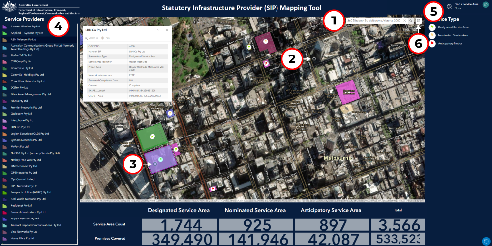
- Enter your address to search for the responsible SIP.
- The search result is shown as a marker on the map. If the marker is shown on an area that is not coloured – NBN Co will be the responsible SIP.
- If the marker falls on a coloured area, click on the area to reveal the SIP and information about the service area.
- Alternatively, you can search for and select a SIP in this alphabetical list, using the scroll bar.
- Once you select a SIP in the list, you can search for its service areas using this ‘Find a service area’ tool.
- You can change the map settings using this icon.